
The route
Home / The route
52 kilometres, subject to the mountain
The route may change
The route may vary due to conditions, so we never provide a GPX file.
It can change at short notice for weather, for ground conditions, or by agreement with the landowners whose land we cross. The route will be well marked and there will be crew at every critical turn point.
Route profile
The race starts at 1 800 metres, reaches its highest point at 2 680 metres (8 793 feet) and has an average on top of 2 560 metres. The cumulative climb is approximately 1 600 metres.
The route starts and ends in the village of Rhodes. The traditional distance is 52 kilometres, subject to conditions.
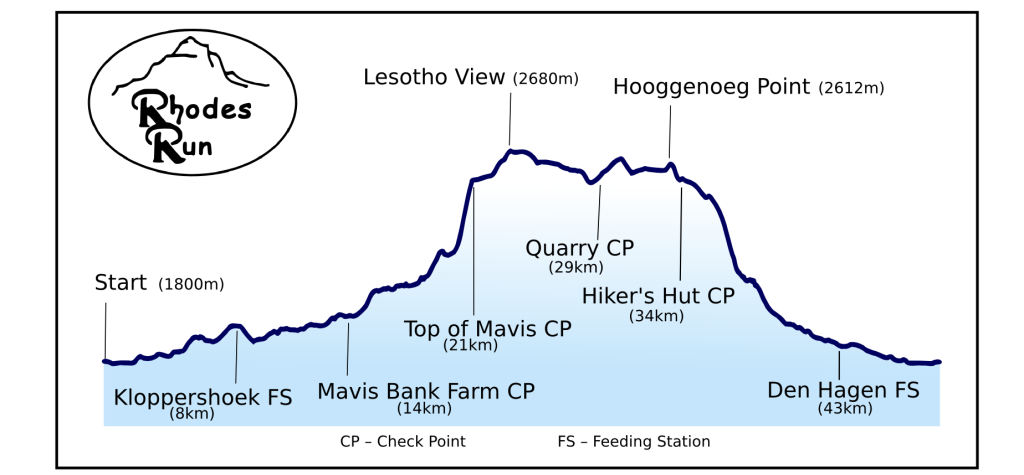
Most of it above 2 500 metres
Leg by leg
Rhodes to Mavis Bank Farm, approximately 13km
Into the Kloof, and up
The top of Mavis Bank, approximately 21km
The Border Road to Tiffindell
The Quarry, approximately 29km
Hooggenoeg and the tufts of terror
The descent, and home
Cut offs at a glance
- Mavis Bank Farm check point, approximately 13km (hard cut off, soft cut off at 2 hours)
- Border Road check point, top of Mavis Bank, approximately 21km
- Quarry check point, approximately 29km
6 hours
- Finish, to qualify as a finisher
9 hours
With thanks to the landowners
The route crosses private farmland. It exists at all because the landowners of this valley allow us to use their land, every year, in the worst weather of the year. We are grateful to them. Please treat their land, their stock and their fences with the respect they deserve.
